Migration of Birds
Routes of Migration
Principle Routes From North America
W.W. cook presented seven of the more important generalized routes
for birds leaving the United States on their way to various wintering grounds
(1915a; fig. 18). When migrants return northward in the spring, they may
follow these same routes, but it is not known for certain whether they
do. These routes are discussed in the following sections.
Atlantic Oceanic Route
Route No. 1 (Fig. 18) is almost entirely oceanic and passes directly
over the Atlantic Ocean from Labrador and Nova Scotia to the Lesser Antilles,
then through this group of small islands to the mainland of South America.
Most of the adult eastern golden plovers and some other shorebirds use
this as their fall route. As we mentioned previously, radar has indicated
strong fall movements of warblers from the New England coast out over the
Atlantic to points south along this route. Since it lies almost entirely
over the sea, this route is definitely known only at its terminals and
from occasional observations made on Bermuda and other islands in its course.
Some of the shorebirds that breed on the Arctic tundra of the District
of Mackenzie (Northwest Territories) and Alaska fly southeastward across
Canada to the Atlantic coast and finally follow this oceanic route to the
mainland of South America. The golden plover may accomplish the whole 2,400
miles without pause or rest, and in fair weather the flocks pass Bermuda
and sometimes even the islands of the Antilles without stopping. Although
most birds make their migratory flights either by day or by night, the
golden plover in this remarkable journey flies both day and night. Since
this plover swims lightly and easily, it may make a few short stops along
the way.
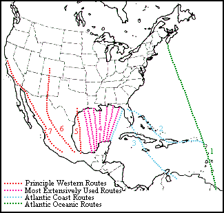 |
| Figure 18. Principal migration routes used by birds in passing
from North America to winter quarters in the West Indies, Central America,
and South America. Route 4 is the one used most extensively while only
a few species make the 2,400 mile flight down Route 1 from Nova Scotia
to South America. |
The Arctic tern follows the Atlantic Ocean route chiefly along the eastern
side of the ocean. Likewise, vast numbers of seabirds such as auks, murres,
guillemots, phalaropes, jaegers, petrels, and shearwaters follow this over-water
route from breeding coasts and islands in the Northern and Southern Hemispheres.
Atlantic Coast Route and Tributaries
The Atlantic coast is a regular avenue of travel, and along it are
many famous points for observing both land and water birds. About 50 different
kinds of landbirds that breed in New England follow the coast southward
to Florida and travel thence by island and mainland to South America (Fig.
18, route 2). The map indicates a natural and convenient highway through
the Bahamas, Cuba, Hispaniola, Puerto Rico, and the Lesser Antilles to
the South American coast. Resting places are affored at convenient intervals,
and at no time need the aerial travelers be out of sight of land. It is
not, however, the favored highway; only about 25 species of birds go beyond
Cuba to Puerto Rico along this route to their winter quarters, while only
six species are known to reach South America by way of the Lesser Antilles.
Many thousands of American coots and wigeons, pintails, blue-winged teal,
and other waterfowl as well as shorebirds, regularly spend the winter season
in the coastal marshes, inland lakes, and ponds of Cuba, Hispaniola, and
Puerto Rico.
Route No. 3 (Fig. 18) is a direct line of travel for Atlantic
coast
migrants en route to South America, although it involves much longer
flights. It is used almost entirely by landbirds. After taking off from
the coast of Florida there are only two intermediate land masses where
the migrants may pause for rest and food. Nevertheless, tens of thousands
of birds of about 60 species cross the 150 miles from Florida to Cuba where
many elect to remain for the winter months. The others negotiate the 90
miles between Cuba and Jamaica, but, from that point to the South American
coast, there is a stretch of islandless ocean 500 miles across. Relatively
few North American migrants on this route go beyond Jamaica. The bobolink
so far outnumbers all other birds using this route that it may be designated
the "bobolink route" (Fig. 19). As traveling companions along this route,
the bobolink may meet vireos, kingbirds, and nighthawks from Florida, Chuck-will's-widows
from the Southeastern States black-billed and yellow-billed cuckoos from
New England, gray-cheeked thrushes from Quebec, bank swallows from Labrador,
and blackpoll warblers from Alaska. Sometimes this scattered assemblage
will be joined by a tanager or a wood thrush, but the "bobolink route"
is not popular with the greater number of migrants.
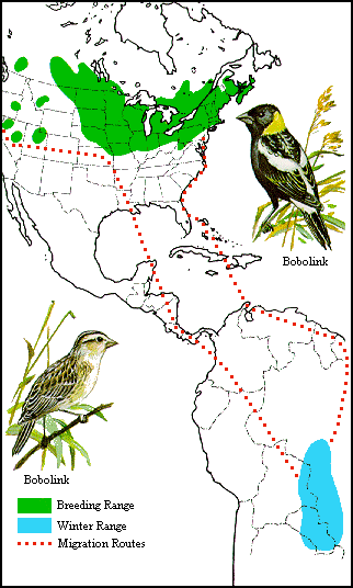 |
| Figure 19. Distribution and migration of the bobolink. In crossing
to South America, most of the bobolinks use route 3 (Fig. 18), showing
no hesitation in making the flight from Jamaica across an islandless stretch
of ocean. It will be noted that colonies of these birds have established
themselves in western areas, but in migration they adhere to the ancestral
flyways and show no tendency to take the short cut across Arizona, New
Mexico, and Texas. |
Formerly, it was thought most North America landbirds migrated to Central
America via the Florida coast, then crossed to Cuba, and finally made the
short flight from the western tip of Cuba to Yucatan. A glance at the map
would suggest this as a most natural route, but, as a matter of fact, it
is practically deserted except for a few swallows and shorebirds or an
occasional landbird storm-driven from its normal course. What actually
happens in the fall is that many of the birds breeding east of the Appalachian
Mountains travel parallel to the seacoast in a more or less southwesterly
direction and, apparently maintaining this same general course from northwestern
Florida, cross the Gulf of Mexico to the coastal regions of eastern Mexico.
They thus join migrants from farther inland in using route No. 4 (Fig.
18).
Routes used by the Atlantic brant merit some detail because their
flight paths were long misunderstood. These birds winter on the Atlantic
coast, chiefly at Barnegat Bay, New Jersey, but depending upon the severity
of the season and the food available, south also to North Carolina. Their
breeding grounds are in the Canadian arctic archipelago and on the coasts
of Greenland. According to the careful studies of Lewis (1937), the main
body travels northward in spring along the coast to the Bay of Fundy, overland
to Northumberland Strait, which separates Prince Edward Island from mainland
New Brunswick and Nova Scotia. A minor route appears to lead northward
from Long Island Sound by way of the Housatonic and Connecticut River Valleys
to the St. Lawrence River.
After spending the entire month of May feeding and resting in
the Gulf of St. Lawrence, the eastern segment of the brant population resumes
its journey by departing overland from the Bay of Seven Island area. The
eastern and larger segment of the population appears to fly almost due
north to Ungava Bay and from there to nesting grounds, probably on Baffin
Island and Greenland. The smaller segment travels a route slightly north
of west to the southeastern shores of James Bay, although east of that
area some of the flocks take a more northwesterly course by descending
the Fort George River to reach the eastern shore of James Bay. Upon their
arrival at either of these two points on James Bay, the brants of this
western segment turn northward and proceed along eastern Hudson Bay to
their breeding grounds in the Canadian Arctic.
In general, the fall migration of the brant follows the routes
utilized in the spring. At this season, the eastern population appears
only on the western and southern shores of Ungava Bay before continuing
their southward journey to the Gulf of St. Lawrence and beyond. Also, it
appears that most of the birds of the western segment, instead of following
the eastern shores of Hudson and James bays, turn southwestward across
the former, by way of the Belcher Islands, to Cape Henrietta Maria, and
from there south along the western shores of James Bay by way of Akimiski
and Charlton Islands. At the southern end of James Bay, they are joined
by those that have taken the more direct route along the east coasts of
the bays and all then fly overland 570 miles to the estuary of the St.
Lawrence River.
The Atlantic coast wintering area receives accretions of waterfowl
from three or four interior migration paths, one of which is of first importance,
as it includes great flocks of canvasbacks, redheads, scaup, Canada geese,
and many black ducks that winter in the waters and marshes of the coastal
region south of Delaware Bay. The canvasbacks, redheads, and scaup coming
from breeding grounds on the great northern plains of central Canada follow
the general southeasterly trend of the Great Lakes, cross Pennsylvania
over the mountains, and reach the Atlantic coast in the vicinity of Delaware
and Chesapeake Bays. Black ducks, mallards, and blue-winged teals that
have gathered in southern Ontario during the fall leave these feeding grounds
and proceed southwest over a course that is apparently headed for the Mississippi
Valley. Many do continue this route down the Ohio Valley, but others, upon
reaching the vicinity of the St. Clair Flats between Michigan and Ontario,
swing abruptly to the southeast and cross the mountains to reach the Atlantic
coast south of New Jersey. This route, with its Mississippi Valley branch,
has been fully documented by the recovery records of ducks banded at Lake
Scugog, Ontario.
Canvasbacks migrate from the prairie pothole country of the central
United States and Canada to many wintering areas in the United States.
This duck has been the subject of a particular study (Stewart, Geis, and
Evans 1958), and its principle migration routes, based on recovery of banded
birds, are shown to follow an important trunk route from the major breeding
area in the prairie provinces of Canada and the northern prairies of the
United States southeastward through the southern Great Lakes area to Chesapeake
Bay, the chief wintering area (Fig. 20). Relatively few canvasbacks proceed
southward along the Atlantic seaboard. A less important route branches
off from the main trunk in the southern Minnesota region and extends south
along the Mississippi Valley to points along the river. Other individuals
of the prairie breeding population fly southward on a broad front to the
gulf coast of Texas and the interior of Mexico, while some proceed southwestward
on a relatively broad path to the northern Pacific coast.
Mackenzie Valley-Great Lakes-Mississippi Valley Route and Tributaries
The route extending from the Mackenzie Valley past the Great Lakes
and down the Mississippi Valley is easily the longest of any in the Western
Hemisphere. Its northern terminus is on the Arctic coast in the regions
of Kotzebue Sound, Alaska, and the mouth of the Mackenzie River, while
its southern end lies in Argentina. Nighthawks, barn swallows, blackpoll
warblers, and individuals of several other species that breed northward
to the Yukon Territory and Alaska must cover the larger part of the route
twice each year.
For more than 3,000 miles-from the mouth of the Mackenzie to the
delta of the Mississippi-this route is uninterrupted by mountains. In fact,
the greatest elevation above sea level is less than 2,000 feet. Because
it is well timbered and watered, the entire region affords ideal conditions
for its great hosts of migrating birds. It is followed by such vast numbers
of ducks, geese, shorebirds, blackbirds, sparrows, warblers, and thrushes
that observers stationed at favorable points in the Mississippi Valley
during the height of migration can see a greater number of migrants than
can be noted anywhere else in the world.
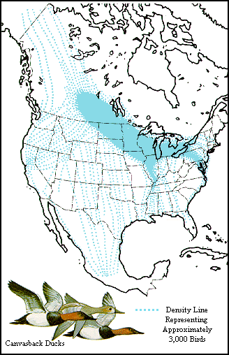 |
| Figure 20. Principal migratory routes of the canvasback. The
major route of t extends from breeding areas in central Canada southeast
across the Great Lakes either south down the Mississippi River or east
to Chesapeake Bay (After Ste et al. 1958). |
When many of these species, including ducks, geese, robins, and yellow-rumped
warblers, arrive at the Gulf coast, they spread out east and west for their
winter sojourn. Others, despite the perils of a trip involving a flight
of several hundred miles across the Gulf of Mexico, fly straight for Central
and South America. This part of the route is a broad "boulevard" extending
from northwestern Florida to eastern Texas and southward across the Gulf
of Mexico to Yucatan and the Isthmus of Tehuantepec (Fig. 18, route 4).
This route appears to have preference over the safer but more circuitous
land or island routes by way of Texas or Florida. During the height of
migration some of the islands off the coast of Louisiana are wonderful
observation points for the student of birds, as the feathered travelers
literally swarm over them.
Present detailed knowledge of the chief tributaries to the Mackenzie-Great
Lakes-Mississippi Valley route relates primarily to waterfowl. Reference
has been made already to the flight of black ducks that reach the Mississippi
Valley from southern Ontario. Some individuals of this species banded at
Lake Scugog, Ontario, have been recaptured in succeeding seasons in Wisconsin
and Manitoba, but the majority was retaken at points south of the junction
of the Ohio River with the Mississippi indicating their main route of travel
from southern Ontario.
A second route that joins the main artery on its eastern side
is the one used by eastern populations of lesser snow geese, including
both blue and white phases, that breed mainly on Southampton Island and
in the Fox Basin of Baffin Island. In the fall these geese work southward
along the shores of Hudson Bay and, upon reaching the southern extremity
of James Bay, take off on their flight to the great coastal marshes of
Louisiana and Texas west of the Mississippi River delta.
Great Plains-Rocky Mountain Routes
This route also has its origin in the Mackenzie River delta and Alaska.
The lesser sandhill cranes, white-fronted geese, and smaller races of the
Canada goose follow this route through the Great Plains from breeding areas
in Alaska and western Canada. It is used chiefly by the pintails and American
wigeons that fly southward through eastern Alberta to western Montana.
Some localities in this area, as for example, the National Bison Range
at Moiese, Montana, normally furnish food in such abundance that these
birds are induced to pause in their migratory movement. Some flocks of
pintails and wigeons move from this area almost directly west across Idaho
to the valley of the Columbia River, then south to the interior valleys
of California. Others leave Montana by traveling southeastward across Wyoming
and Colorado to join other flocks moving southward through the Great Plains.
Observations made in the vicinity of Corpus Christi, Texas, have
shown one of the short cuts (Fig. 18, route 5) that is part of the great
artery of migration. Thousands of birds pass along the coast to the northern
part of the State of Veracruz, Mexico. Coastal areas along the State of
Tamaulipas to the north are arid and so entirely unsuited for frequenters
of moist woodlands that it is probable that much, or all, of this part
of the route for these species is a short distance off shore. It is used
by such woodland species as the golden-winged warbler, the worm-eating
warbler, and the Kentucky warbler.
Pacific Coast Route
Although it does present features of unusual interest, the Pacific
coast route is not as important as some of the others described. Because
of the equable conditions that prevail, many species of birds along the
coast from the northwestern states to southeastern Alaska either do not
migrate or else make relatively short journeys. This route has its origin
chiefly in western Alaska, around the Yukon River delta. Some of the scoters
and other sea ducks of the north Pacific region as well as the diminutive
cackling Canada goose of the Yukon River Delta use the coastal sea route
for all or most of their southward flight. The journey of the cackling
goose, as shown by return records from birds banded at Hooper Bay, Alaska,
has been traced southward across the Alaskan Peninsula and apparently across
the Gulf of Alaska to the Queen Charlotte Islands. The birds then follow
the coast line south to near the mouth of the Columbia River, where the
route swings toward the interior for a short distance before continuing
south by way of the Willamette River Valley. The winter quarters of the
cackling goose are chiefly in the vicinity of Tule Lake, on the Oregon-California
line, and in the Sacramento Valley of California, although a few push on
to the San Joaquin Valley.
A tributary of this "flyway" is followed by Ross' goose, which
breeds in the Perry River district south of Queen Maud Gulf and other areas
farther east on the central Arctic coast of Canada (Fig. 21). Its fall
migration is southwest and south across the barren grounds to Great Slave
and Athabaska Lakes, where it joins thousands of other waterfowl bound
for winter homes along the eastern coast of the United States and the Gulf
of Mexico. But when Ross' geese have traveled south approximately to the
northern boundary of Montana, most of them separate from their companions
and turn southwest across the Rocky Mountains to winter in California.
In recent years a few Ross' geese have been found wintering east of the
Rocky Mountains along with flocks of lesser snow geese and may be correlated
with an eastward extension of their breeding range.
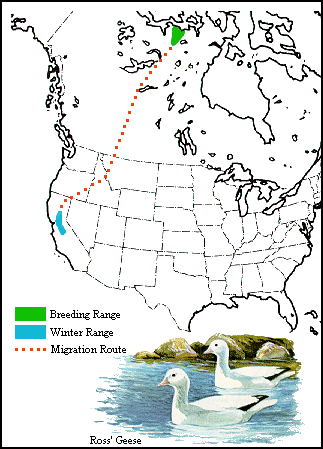 |
| Figure 21. The breeding range, wintering range, and main migration
route of Ross' geese. This is the only species of which practically all
members breed in the Arctic, migrate south through the Canadian prairie,
and upon reaching the United States, turn to the southwest rather than
the southeast. The southern part of this route, however, is followed by
some mallards, pintails, wigeons, and other ducks. |
The southward route of those migratory landbirds of the Pacific area
that leave the United States in winter extends chiefly through the interior
of California to the mouth of the Colorado River and on to winter quarters
in western Mexico (Fig. 18, routes 6 and 7).
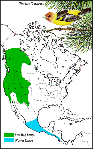 |
| Figure 22. Breeding and wintering ranges of the western tanager.
See Fig. 23 for the spring route taken by the birds breeding in the northern
part of the range. |
The movements of the western tanager show a migration route that is
in some ways remarkable. The species breeds in the mountains from the northern
part of Baja California and western Texas north to northern British Columbia
and southwestern Mackenzie. Its winter range is in two discontinuous areas
southern Baja California and eastern and southwestern Mexico south to Guatemala
(Fig. 22). During spring migration the birds appear first in western Texas
and the southern parts of New Mexico and Arizona about April 20 (Fig. 23).
By April 30 the vanguard has advanced evenly to an approximate east-west
line across central New Mexico, Arizona, and southern California. By May
10 the easternmost birds have advanced only to southern Colorado, while
those in the far west have reached northern Washington. Ten days later
the northward advance of the species is shown as a great curve, extending
northeastward from Vancouver Island to central Alberta and thence southeastward
to northern Colorado. Since these tanagers do not reach northern Colorado
until May 20, it is evident those present in Alberta on that date, instead
of traveling northward through the Rocky Mountains, their summer home,
actually reached there by a route that carried them west of the Rockies
to southern British Columbia and thence eastward across the still snowy
northern Rocky Mountains.
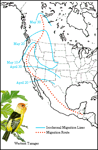 |
| Figure 23. Migration of the western tanager. The birds that
arrive in eastern Alberta by May 20 do not travel northward along the eastern
base of the Rocky Mountains, because the vanguard has then only reached
northern Colorado. Instead the isochronal lines indicate that they migrate
north through California, Oregon, and Washington and then cross the Rockies
in British Columbia. |
Pacific Oceanic Route
The Pacific oceanic route is used by the Pacific golden plover, bristle-thighed
curlew, ruddy turnstone, wandering tattler and other shorebirds. The ruddy
turnstone, and probably other shorebirds, migrating from the islands of
the Bering Sea, have an elliptical route that takes them southward via
the islands of the central Pacific and northward along the Asiatic coast.
In addition, many seabirds that breed on far northern and southern coasts
or islands migrate up and down the Pacific well away from land except when
the breeding season approaches.
The Pacific golden plover breeds chiefly in the Arctic coast region
of Siberia and in a more limited area on the Alaskan coast. Some of the
birds probably migrate south via the continent of Asia to winter quarters
in Japan, China, India, Australia, New Zealand, and Oceania. Others evidently
go south by way of the Pacific Ocean to the Hawaiian Islands and other
islands of the central and southern Pacific. Migrating golden plovers have
been observed at sea on a line that apparently extends from Hawaii to the
Aleutian Islands; it appears certain some of the Alaskan birds make a nonstop
flight across the sea from Alaska to Hawaii. While it would seem incredible
that any birds could lay a course so accurately as to land on these small
isolated oceanic islands, 2,000 miles south of the Aleutians, 2,000 miles
west of Baja California, and nearly 4,000 miles east of Japan, the evidence
admits only the conclusion that year after year this transoceanic round-trip
journey between Alaska and Hawaii is made by considerable numbers of golden
plovers.
Arctic Routes
Some Arctic nesting birds retreat only a short distance south in the
winter. These species include the red-legged kittiwake, Ross' gull, emperor
goose, and various eiders. The latter group of ducks winter well south
of their nesting areas but nevertheless remain farther north than do the
majority of other species of ducks. The routes followed by these birds
are chiefly parallel to the coast and may be considered as being tributary
either to the Atlantic or Pacific coast routes. The heavy passage of gulls,
ducks, black brants, and other water birds at Point Barrow, Alaska, and
other points on the Arctic coast, has been noted by many observers. The
best defined Arctic route in North America is the one following the coast
of Alaska.
A migration route, therefore, may be anything from a narrow path
closely adhering to some definite geographical feature, such as a river
valley or a coastline, to a broad boulevard that leads in the desired direction
and follows only the general trend of the land mass. Oceanic routes appear
to be special cases that are not fully understood at the present time.
Also it must be remembered that all the main routes contain a multitude
of tributary and separate minor routes. In fact, with the entire continent
of North America crossed by migratory birds, the different groups or species
frequently follow lines that may repeatedly intersect those taken by others
of their own kind or by other species. The arterial or trunk routes, therefore,
must be considered merely as indicating paths of migration on which the
tendency to concentrate is particularly noticeable.
Previous Section -- Routes of Migration
Return to Contents
Next Section -- Patterns of Migration